Introduction: The Capital Risk of Construction Blindspots
Here’s something that most developers won’t say out loud, but every developer in the industry knows in their heart.
In a market like Mumbai – or industrial belts like Bhiwandi – a week of uncertain progress is not just an inconvenience. It kills the one thing that actually makes the capital flow: trust.
Run a multi-acre project, you already know the drill. Huge budgets, tight deadlines, and a long list of stakeholders that get itchy the minute they can’t see what’s really going on on site.
If you’re still in the early planning phase, it’s worth reading what we covered on pre-construction drone surveying in Bhiwandi — getting this groundwork right before the first shovel hits dirt saves a lot of pain later.
So then what is the real issue? Most progress reporting still involves someone walking the site physically, or a few grainy ground-level photos sent over WhatsApp at 11pm.
That’s not transparency for an investor who’s sitting in Dubai, or a fund manager who just can’t show up every week. That is a blind spot, and blind spots cost money.
This article walks you through how phase-by-phase drone tracking closes that gap – so you can build with proof on the table, not just promises.
Why Traditional Progress Reports Fail Modern Stakeholders
Ground-level photography was never built for the scale developers operate at now. It’s a 2015 tool trying to do a 2026 job.
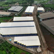
No spatial perspective. A phone photo from ground level isn’t going to show a 50-acre warehouse foundation layout. It definitely won’t help you track roof truss placement across a sprawling industrial span — there’s just no angle for it.
Errors surface late, and late is costly. A grading mistake or a utility misalignment caught three weeks after the fact? That can quietly wreck an entire launch timeline.
Trust has gotten harder to earn. Investors today aren’t satisfied with a polished spreadsheet or a confident phone call. They want something they can verify on their own, without taking anyone’s word for it.
The Mechanics of Drone-Driven Site Tracking
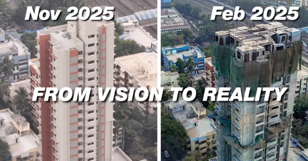
From Vision to Reality: A 9-month side-by-side construction timeline mapping project in Goregaon East executed by Cinematic360, documenting the precise transition from raw concrete frameworks to a completed architectural landmark.
Aerial intelligence does what ground reporting never could – it converts a messy construction field constantly shifting into something you can actually measure and hand to an investor with a straight face.
We’ve gone deeper into the broader use case in our piece on commercial drone photography for Mumbai real estate developers, but here’s how it plays out specifically for progress tracking.
Continuous orthomosaic time-lapses.
Same drone. Same co-ordinates. Every week, or every month, as the project goes. This gradually builds a very accurate orthomosaic map that shows exactly how the site has developed, phase by phase. No guesswork, no “I think we’re on track” — just a visual record that can’t lie.
For instance, check out our recent 9 months structural mapping project for premium residential high-rise in Jay Prakash Nagar, Goregaon East. Manual drone mapping was not an option with the extreme urban density and wind shear from passing trains, tightly packed along one of Mumbai’s busiest suburban transit corridors. We locked down exact, automated waypoints and flew the same coordinates from February 2025 to November 2025, documenting the perfect metamorphosis of the tower from a bare concrete shell to a finished architectural landmark. The time-stamped visual data not only met strict MahaRERA completion milestones, but also provided the developer with irrefutable proof-of-work to fast-track handovers to buyers and build rock-solid trust with investors.
Infrastructure and utility cross-checking.
Here is where the technical value really comes in. Engineering teams can overlay the original CAD blueprints directly onto live aerial footage; roads are checked against planned alignment, retaining walls are verified for placement, and power grid routing is caught before it becomes an expensive fix, instead of a cheap one.
Three Ways Drone Tracking Actually Speeds Up Delivery
Milestone verification: How Cinematic360 uses precise aerial intelligence to document specific structural heights—like reaching the 15th floor—for real estate developer blueprints.
Remote investor relations stop being a guessing game.
If you are raising institutional capital, or courting NRI investors who can’t visit the site themselves, drone footage is your best piece of evidence. Instead of another status update email, send a high-def aerial walkthrough instead. Watch as funding conversations move so much faster when there’s nothing left to argue about.
MahaRERA doesn’t take it lightly when it comes to timeline declarations, and you already know that. Having a clear, time-stamped visual record of every phase is not just a luxury; it’s a safeguard against disputes, buyer complaints, and compliance issues you definitely want to avoid. For the complete details, our RERA. compliance documentation guide covers exactly what builders need on file.
Engineering teams stay aligned without endless site visits.
Architects, structural engineers, and contractors no longer need to travel for a weekly check-in. One high-resolution flight provides everyone with the same bird’s-eye view, which can be reviewed remotely in a secure data room. This saves hours each week on every active project.
Build with Transparency, Scale with Cinematic360
In Mumbai’s commercial and industrial real estate market, the developers winning the long game aren’t the loudest ones. They’re the ones building with data-backed transparency, so nobody has to ask too many questions.
Ditch the outdated photo-and-spreadsheet routine. Continuous aerial tracking protects your reputation, keeps your backers calm, and makes handovers genuinely smooth instead of a scramble.
[Request a Continuous Progress Tracking Subscription Quote from Cinematic360]